


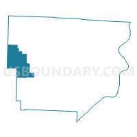
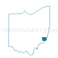
PRECINCT FRANKLIN, Monroe County, Ohio
About
Outline

Summary
| Unique Area Identifier | 650121 |
| Name | PRECINCT FRANKLIN |
| County | Monroe County |
| State | Ohio |
| Area (square miles) | 23.79 |
| Land Area (square miles) | 23.78 |
| Water Area (square miles) | 0.00 |
| % of Land Area | 99.99 |
| % of Water Area | 0.01 |
| Latitude of the Internal Point | 39.72942660 |
| Longtitude of the Internal Point | -81.28410680 |
Maps

Graphs
Select a template below for downloading or customizing gragh for PRECINCT FRANKLIN, Monroe County, Ohio


Neighbors
Neighoring Voting District (by Name) Neighboring Voting District on the Map
- ELK Voting District, Noble County, OH
- MARION Voting District, Noble County, OH
- PRECINCT BETHEL, Monroe County, OH
- PRECINCT SENECA, Monroe County, OH
- PRECINCT SUMMIT, Monroe County, OH
- PRECINCT WASHINGTON, Monroe County, OH
- PRECINCT WAYNE, Monroe County, OH
- STOCK Voting District, Noble County, OH
Top 10 Neighboring County Subdivision (by Population) Neighboring County Subdivision on the Map
- Marion township, Noble County, OH (671)
- Summit township, Monroe County, OH (647)
- Washington township, Monroe County, OH (511)
- Seneca township, Monroe County, OH (486)
- Franklin township, Monroe County, OH (427)
- Wayne township, Monroe County, OH (362)
- Bethel township, Monroe County, OH (347)
- Elk township, Noble County, OH (333)
- Stock township, Noble County, OH (325)
Top 10 Neighboring Place (by Population) Neighboring Place on the Map
Top 10 Neighboring Unified School District (by Population) Neighboring Unified School District on the Map
Top 10 Neighboring State Legislative District Lower Chamber (by Population) Neighboring State Legislative District Lower Chamber on the Map
Top 10 Neighboring State Legislative District Upper Chamber (by Population) Neighboring State Legislative District Upper Chamber on the Map
Top 10 Neighboring 111th Congressional District (by Population) Neighboring 111th Congressional District on the Map
Top 10 Neighboring Census Tract (by Population) Neighboring Census Tract on the Map
- Census Tract 9683, Noble County, OH (4,051)
- Census Tract 9667, Monroe County, OH (3,773)
- Census Tract 9669, Monroe County, OH (3,319)
- Census Tract 9685, Noble County, OH (3,210)
Top 10 Neighboring 5-Digit ZIP Code Tabulation Area (by Population) Neighboring 5-Digit ZIP Code Tabulation Area on the Map
- 43724, OH (9,201)
- 43754, OH (1,542)
- 45745, OH (1,140)
- 43788, OH (865)
- 45734, OH (549)
- 43786, OH (32)